


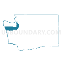
Voting District 701, Jefferson County, Washington
About
Outline

Summary
| Unique Area Identifier | 684522 |
| Name | Voting District 701 |
| County | Jefferson County |
| State | Washington |
| Area (square miles) | 1.39 |
| Land Area (square miles) | 0.60 |
| Water Area (square miles) | 0.79 |
| % of Land Area | 43.11 |
| % of Water Area | 56.89 |
| Latitude of the Internal Point | 48.11350530 |
| Longtitude of the Internal Point | -122.76204350 |
Maps


Graphs
Select a template below for downloading or customizing gragh for Voting District 701, Jefferson County, Washington


Neighbors
Neighoring Voting District (by Name) Neighboring Voting District on the Map
- Voting District 702, Jefferson County, WA
- Voting District 703, Jefferson County, WA
- Water: Admiralty Inlet, Jefferson County, WA
- Water: Port Townsend Bay, Jefferson County, WA